Typhoon "Moranti" landed this morning in Xiamen, China 8 provinces and cities along the coast were strong storm | typhoons | Moranti _ news
Today the weather network in China (15th) before and after 3:05 A.M., the 14th typhoon this year "Moranti" xiangan district in Xiamen, Fujian province's coastal land, land strength for strong Tornado (48 m/s, 15). Expect "Moranti" at a speed of 20 kilometers per hour to the north-north-westerly turn direction, intensity decreases. Under its influence, the next three days, 8 provinces such as Fujian, Guangdong will suffer a severe rain weather, especially in today's rain-affected the most.
 The morning of 14th, Quanzhou, Fujian province wind billboards were blown down. (Source: Quanzhou net)
As the world's strongest Typhoon this year, "Moranti" is not illusory. By its effect, yesterday up, Taiwan, and Fujian and the Guangdong coastal has appeared storm, monitoring displayed, 14th 8 o'clock to 20 o'clock, Zhejiang East and Fujian Northeast appeared rain or storm, Zhejiang Wenzhou, and Fujian Ningde Council to drop storm (100~161 mm), Zhejiang Wenzhou and Fujian Ningde Council to maximum hours rainfall has 56 mm and 42 mm; Fujian East, and Zhejiang Southeast coastal appeared 8~10 level instantaneous Gale, Fujian Xiamen, and Quanzhou, and Putian, and Fuzhou, to Council to instantaneous maximum wind up 11 ~13 level, Quanzhou, Putian, Fuzhou and other coastal and Island Council level 12 Gale 5-10 hours duration. In addition, the 13th 00 o'clock until 14th 20 o'clock, Taiwan Eastern storm rainfall or torrential, Pingtung to 500~777 mm; Taiwan coastal regions 11~13-level gust, Orchid Island and the dongji Islands up to level 17, resulting in Taiwan Super million power outages, large-area flight cancellations, Xiamen, Fujian, 10 bridge closed, Nanchang, Shanghai, a number of trains stopped operating.
3:05 A.M. today, Typhoon "Moranti" was 24.57 degrees north latitude, longitude 118.23, namely xiangan, Xiamen, Fujian's coastal land, central pressure to 94,500 PA, maximum winds near 15 level (around 48 mph, 180 km/h).
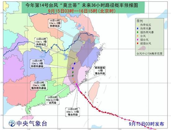 The Central Meteorological Station expects "Moranti" at a speed of 20 km per hour to the north-north-westerly turn direction, intensity decreases.
In its powerful of power Xia, Central Observatory is expected to, future three days, Guangdong East, and Fujian East and southern, and Zhejiang East, and Jiangxi East, and Shanghai, and Anhui Southeast, and Jiangsu in the southern and Taiwan East, to of part area will has storm, Council to has King storm; Taiwan East of ocean, and bus Strait, and Taiwan Strait, and Sea North Sea and the Taiwan southern and coastal, and Fujian East and southern, and Guangdong East and the coastal, and Zhejiang Southeast coastal, and East Southern, to wind will gradually increased to 7~10 level, Wind 11~12 part or region level, local waters of 13-17 even more.
Typhoon "Moranti" influence a wide range of wind and rain will affect Taiwan, Fujian, Guangdong, Shanghai, Jiangsu, Anhui, Zhejiang, Jiangxi, in 8 provinces. Since the landing time coincided with the Mid-Autumn Festival, comes as the astronomical tide period, may result in "wind, rain, tides" and its secondary disaster caused by overlay.
Global wind King "Moranti", what do we do?
Meteorologists warned that the storm hit during the Moon Festival holiday, travel, travel for more staff, so should strengthening Typhoon preparedness.
1。 Large rain area, or affected holiday travel traffic. Roads, railways, flights may be affected by the typhoon, such as storm impact will halt flights were delayed, roads closed, sea phenomenon, some impact on the public holiday. Therefore, the public needs to be concerned about the weather forecast, and pay attention to weather changes in advance, arranging travel plans, and lines. In addition, the need to carry rain gear when they go out, get rain ready;
2。 Fujian, Guangdong and coastal storm surges superimposed effects, scenic awareness. In defense, Fujian, Guangdong and other coastal areas need to guard against wind, rain, adverse effects of superimposed flashes, especially tourism scenic area and the island needs to strengthen safety evacuation management;
3。 Guard against secondary disasters, continuous rainfall alert River Super police force. In addition, under the influence of heavy precipitation, southern Anhui, Zhejiang and Fujian in the Southeast South, Eastern Guangdong and other parts of the mountain torrents, higher risk of geological disasters meteorological, advance defense of secondary disasters. In precipitation intensity, long duration area, rivers exceeded the warning level.

Autumn typhoons often have characteristics of more serious harm to agricultural production in China, "Moranti" is no exception, currently at most parts of southern rice filling mature and late rice ear earing period, fisheries are in the fall fishing season production season to guard against "Moranti" brings strong winds and big waves, heavy rain will have adverse effects on agricultural production.
Responsible editor: Sun Ailin SN146
Article keywords:Typhoon Moranti
I want feedback
Save a Web page
China weather network
台风“莫兰蒂”今天早晨登陆中国厦门沿海 8省市将遭强风雨|台风登陆|莫兰蒂_新闻资讯
中国天气网讯 今天(15日)凌晨3点05分前后,今年第14号台风“莫兰蒂”在福建厦门翔安区沿海登陆,登陆时强度为强台风级(48米/秒,15级)。预计“莫兰蒂” 将以每小时20公里左右的速度向北偏西转偏北方向移动,强度逐渐减弱。受其影响,今后三天,福建、广东等8省市将遭遇强风雨天气,尤以今天的风雨影响最 大。
14日上午,福建泉州大风致广告牌被吹落。(来源:泉州网) 作为今年以来全球最强台风,“莫兰蒂”绝非徒有虚名。受其影响,昨天起,台湾、福建及广东沿海已经出现狂风暴雨,监测显 示,14日8时至20时,浙江东部和福建东北部出现大雨或暴雨,浙江温州、福建宁德局地降大暴雨(100~161毫米),浙江温州和福建宁德局地最大小时 雨量有56毫米和42毫米;福建东部、浙江东南部沿海出现8~10级瞬时大风,福建厦门、泉州、莆田、福州等地局地瞬时最大风力达11~13级,泉州、莆 田、福州等地沿海和岛屿局地12级以上大风持续时间有5~10小时。另外,13日00时至14日20时,台湾东部出现大暴雨或特大暴雨,屏东局地 500~777毫米;台湾沿海地区出现11~13级阵风,兰屿和东吉岛最大达17级,造成台湾超万户停电,福建厦门大面积航班取消、10座大桥封闭,上 海、南昌多辆列车停运。
今天凌晨3时05分,台风“莫兰蒂”于北纬24.57°,东经118.23°,也就是福建厦门翔安区沿海登陆,中心气压为945百帕,最大风力为15级(约48米/秒,180公里/小时)。
中央气象台预计,“莫兰蒂”将以每小时20公里的速度向北偏西转偏北方向移动,强度逐渐减弱。 在其强大的威力下,中央气象台预计,未来三天,广东东部、福建东部和南部、浙江东部、江西东部、上海、安徽东南部、江苏中南部和台湾东部等地的部分 地区将有大暴雨,局地有特大暴雨;台湾以东洋面、巴士海峡、台湾海峡、南海北部海面及台湾南部和沿海、福建东部和南部、广东东部及沿海、浙江东南部沿海、 东海南部等地风力将逐渐加大到7~10级,部分海域或地区风力有11~12级,局部海域可达13-17级甚至以上。
台风“莫兰蒂”影响范围广,风雨过程将影响台湾、福建、广东、浙江、江西、上海、江苏、安徽8省市。由于登陆时间恰逢中秋节,正值天文大潮期间,可能会造成“风、雨、潮”及其引发的次生灾害叠加。
全球风王“莫兰蒂”来了,我们怎么办?
气象专家提醒,此次台风来袭正值中秋小长假期间,出行、旅游人员较多,因此更应加强台风的防范工作。
1。风雨面积大,小长假出行交通或受影响。公路、铁路、航班等可能会受到台风带来的风雨影响,会出现航班延误、公路封闭、海运停运的现象,对公众小长假出行造成一定影响。因此,公众需及时关注天气预报,提前留意天气变化,合理安排出行计划及线路。另外,外出时需携带雨具,做好防雨准备;
2。闽粤沿海或受风雨潮叠加影响,景区加强防范。在防御方面,福建、广东等沿海地区需防范风、雨、潮叠加带来的不利影响,尤其是景区及涉岛旅游需加强人员疏散等安全管理工作;
3。防范次生灾害,持续降水警惕河流超警。此外,受强降水影响,安徽南部、浙江东南部、福建南部、广东东部等地的部分地区发生山洪、地质灾害的气象风险较高,需要提前做好次生灾害的防御。在降水强度大、持续时间长的区域,河流还可能出现超警戒水位的情况。
秋天的台风往往具有对中国农业生产造成的危害更为严重的特点,“莫兰蒂”也不例外,当前正值南方大部分地区中稻灌浆成熟、晚稻孕穗抽穗的关键时期,渔业正处于秋季渔汛生产旺季,要警惕“莫兰蒂”带来的强风、大浪、暴雨将对农业生产带来不利影响。
责任编辑:孙爱林 SN146
文章关键词: 台风登陆 莫兰蒂
我要反馈
保存网页
中国天气网