Typhoon "Moranti" no go, "Malka"
Xinhua News Agency, Beijing, September 15-, super Typhoon "Moranti" impact on China's coast has not receded, Typhoon "Malka" and headed for the East China Sea. 15th from the national marine forecasting station was informed that although "Malka" is expected to be in the offshore shift northward, but will bring to East China coastal storm surges and waves the impact of disasters.
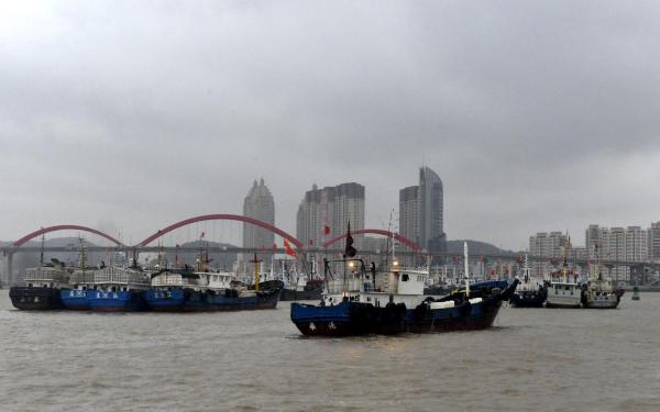 On September 14, 2016, Zhoushan City, Zhejiang Province, shenjiamen port gathered tens of thousands of fishing boats from Kaohsiung "Moranti", "Malka". Dongfang IC
"Moranti" effect is expected on 15th to 16th, Wenzhou City, Zhejiang Province, Fujian province, Zhangzhou city coastal storm surge of a 30 cm to 70 cm, ruian, Zhejiang, in the above-mentioned sections aojiang Fujian and Guanxi tide station will occur the night of 15th to meet the local blue warning water level high.
Typhoon "Malka" Center 15th 14 o'clock in Taiwan on the Northwest Pacific Ocean 960 kilometers southeast of Hualien, is expected to "Malka" towards Taiwan East close to the ocean, then move gradually turned to the North, in the East China Sea northward. "Malka" raging waves swept across the sea will form to the raging sea area. Under its influence, is expected to start 16th, Taiwan East Ocean, fishing the waters around the Islands, the Taiwan Straits and the East China Sea storm large, Fujian, Zhejiang, and Shanghai will also appear once the waves along the coast. National Marine forecasting station warned relevant ship returned to Hong Kong in time to avoid the waves of the sea-going job; all unit wave wave-avoidance measures taken in advance.
"Malka" will give China from 16th to 18th in Fujian, Zhejiang, Shanghai, brought a storm surge from the South to the North along the coast, minjiang River in Fujian, Zhejiang Wenzhou, Taizhou and the Bay area coast to seriously affect the Bank.
Storm surge in the national marine forecasting station chief forecaster Wu Shaohua said that due to the current "Malka" into Taiwan after the ocean surface East of, its path and speed is still uncertain, does not eliminate the possibility of storm surge warning levels for the red, coastal units to moisture prepared.
This year, "Malka" effects of superposition of astronomical tide and storm surge, tidal surge levels will increase, high tide will also increase. National Marine forecasting station warned, Qiantang River tide is spectacular at the same time, will also pose a risk to the tide, the tide must pay special attention to the safety of the public.
(Editors: Liu Cheng UN649)
2016-09-15 21:20:20
Surging
台风“莫兰蒂”未走,“马勒卡”又来了
新华社北京9月15日电,超强台风“莫兰蒂”对中国沿海的影响尚未消退,台风“马勒卡”又直奔中国东海而来。记者15日从国家海洋预报台获悉,虽然“马勒卡”预计将在近海转向北上,但仍将给中国华东沿海带来风暴潮和海浪灾害影响。
2016年9月14日,浙江省舟山市,沈家门渔港云集上万艘渔船躲避台风“莫兰蒂”、“马勒卡”。 东方IC 图 受“莫兰蒂”的影响,预计15日下午到16日上午,浙江省温州市到福建省漳州市沿海将出现30厘米到70厘米的风暴增水,上述岸段内的浙江瑞安、鳌江和福建琯头潮位站将于15日夜间出现达到当地蓝色警戒潮位的高潮位。
台风“马勒卡”的中心15日14时位于台湾花莲东南方向960公里的西北太平洋洋面上,预计“马勒卡”将逐渐向台湾以东洋面靠近,随后逐渐转向偏北方向移动,在华东近海北上。“马勒卡”扫过海面将形成狂浪到狂涛区。受其影响,预计16日开始,台湾以东洋面、钓鱼岛附近海域、台湾海峡、东海海域风浪较大,福建、浙江、上海沿海也将出现一次海浪过程。国家海洋预报台提醒在相关海域航行作业的船舶及时回港避浪;沿海各有关单位提前采取防浪避浪措施。
“马勒卡”将在16日至18日给中国福建、浙江、上海沿海自南向北带来一次风暴增水过程,其中福建闽江口、浙江温州、台州及杭州湾一带沿海为严重影响岸段。
国家海洋预报台风暴潮首席预报员吴少华表示,由于目前“马勒卡”进入台湾以东洋面后,其路径及速度快慢尚存在不确定性,不排除风暴潮预警级别为红色的可能,沿海相关单位要做好防潮准备。
今年受“马勒卡”的影响,风暴增水与天文大潮的叠加,潮水汹涌程度将会加剧,潮高也将增加。国家海洋预报台提醒,钱塘江大潮极为壮观的同时,也将给观潮带来危险,广大公众在观潮时一定要特别注意安全。
(责任编辑:刘盛钱 UN649)
2016-09-15 21:20:20
澎湃