Typhoon "Malka" 17th over Taiwan North-East
China Central meteorological station the weather network September 17 06 o'clock yellow Typhoon warning was issued:
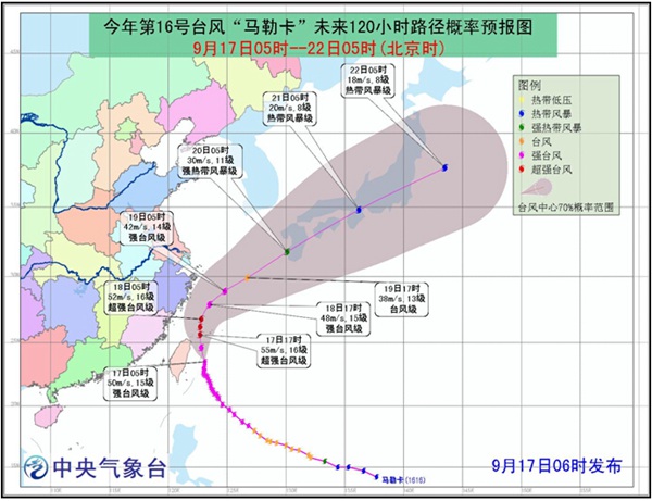
This year 16th, Typhoon "Malka" (strong typhoon level) of Center (17th) 5 o'clock in the morning is located in China Taiwan Hualien East partial South about 160 km of ocean Shang, is latitude 23.5 degrees, n 123.1 degrees, Center near maximum wind has 15 level (50 m/s), Center most depression 94,000 PA, seven level ring RADIUS 280~320 km, 10 level ring RADIUS 100 km, 10 level ring RADIUS 50 km.
Is expected to, "Malka" will to each hours 15 to 20 km of speed to North West direction mobile, strength maintained or slightly has enhanced (15-16 level, 50~55 m/s); 17th afternoon wipe had Taiwan island Northeast into China East Sea, and gradually steering partial north direction mobile; 18th evening began, "Malka" in Zhejiang East offshore sea steering Northeast direction mobile, gradually to Japan West southern coastal near.
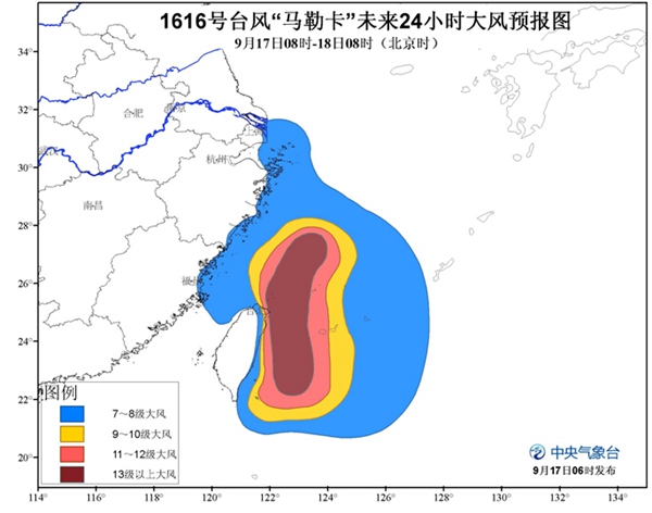
Wind forecasting September 17 08 o'clock until 18th 08 o'clock, Yangtze River estuary, coastal Zhejiang Province, Department of northern coast of Fujian province, East China Sea, Taiwan East of ocean Northeast, the Taiwan Strait, Taiwan Eastern and northern coasts, Bashi part will have 8-10 winds, part of wind 11-13, "Malka" Center through wind up near 14-16, gust 17 levels.
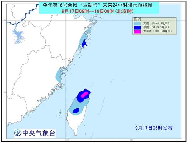
Precipitation forecast September 17 08 o'clock until 18th 08 o'clock, Zhejiang East Coast, heavy rain in some areas of the northeast coast of Fujian province, rains; Taiwan with heavy rain in the North, heavy rain (100-170 mm).
(Editors: Xu Yonggang UN006)
2016-09-17 09:38:13
China weather network
台风“马勒卡”17日下午擦过台湾东北部
中国天气网讯 中央气象台9月17日06时发布台风黄色预警:
今年第16号台风“马勒卡”(强台风级)的中心(17日)早晨5点钟位于中国台湾省花莲市东偏南方大约160公里的洋面上,就是北纬23.5度,东经123.1度,中心附近最大风力有15级(50米/秒),中心最低气压940百帕,七级风圈半径280~320公里,十级风圈半径100公里,十级风圈半径50公里。
预计,“马勒卡”将以每小时15到20公里的速度向北偏西方向移动,强度维持或略有增强(15-16级,50~55米/秒);17日下午擦过台湾岛东北部进入中国东海海面,并逐渐转向偏北方向移动;18日傍晚开始,“马勒卡”在浙江东部近海海面转向东北方向移动,逐渐向日本西南部沿海靠近。
大风预报:9月17日08时至18日08时,长江口区、浙江沿海、福建北部沿海、东海大部、台湾以东洋面、台湾海峡东北部、台湾东部和北部沿海、巴士海峡的部分海域将有8-10级大风,部分海域风力有11-13级,“马勒卡”中心经过的附近海域风力可达14-16级,阵风17级。
降水预报:9月17日08时至18日08时,浙江东部沿海、福建东北部沿海等的部分地区有大雨,局地暴雨;台湾中北部有大到暴雨,局地大暴雨(100-170毫米)。
(责任编辑:徐永刚 UN006)
2016-09-17 09:38:13
中国天气网