China's largest freshwater lake in the desert area reduced by half, Shaanxi and Inner Mongolia province accused each other Plover | | | narrow _ the desert news
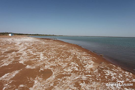
According to voice of reports the news vertical and horizontal, located in ejin Horo banner in Shenmu County in Shaanxi Province and Inner Mongolia border regions of the hongjiannao Lake, is a national water conservancy scenic area and natural reserve. Hongjiannao lake water area's largest in history for the 1969 67 square kilometers, is China's largest desert lake and relict gull reproductive and Habitat of the world's largest, is known as "the Pearl of the desert."
In recent years, the hongjiannao is facing severe crisis, upstream interception of surface feeder dam, downstream Lakes were developed into tourist attractions. At present, the heyday of the Lake area have shrunk by nearly half, and both sides of the junction of Shaanxi-Inner Mongolia refers to each other damage, protection of lakes across the region difficult.
Hongjiannao Lake in Shenmu North-, South-East along the MU us desert. According to the Director, Office of Shenmu hongjiannao scenic Dang Yabo introduced, due to reduced water, hongjiannao lake water PH value has been as high as 9.8, originally 17 wild freshwater fish living in the Lake have been extinct, and another species to survive--the number of relict gull also dropped sharply. Party Asia believes that cause hongjiannao Lake ecological natural sinks into the Earth's surface is the main reason for this drastic change is truncated. Since 2006, after the start, ejin Horo banner in Inner Mongolia respectively in the two dams on the river interception. Has no water to the Lake area. Because hongjiannao Lake area between year is 2000 mm rainfall per year between 350 to 400 mm. Evaporation and rainfall of 1600 mm gap is mainly carried out by the rivers recharging. After the closure of the River, you can't make up this gap.
Party Asian wave introduced around hongjiannao lake water supply mainly depends on surface water. Which flows through the ejin Horo banner of Saskatchewan River and Python gaituhe is a major water river hongjiannao, accounted for more than half of its surface runoff water. And da BA Dang Yabo said closure is the two rivers. Who lives in Saskatchewan downstream of the reservoir of Inner Mongolia Ulan tolgoi village xiaozailin said that since 2004, after completion, river run dry, many (the villagers) planted Salix. Now, encountered years of abundant rain River into wetlands, small rain season the villagers can walk through to the other side.
So naturally into the hongjiannao River to where? What causes saxophone reservoir which was built in 2004 never discharge? Inner Mongolia Erdos city water Conservancy Bureau Deputy Director introduced rivers, Ordos, respectively in the Saskatchewan River and Python construction of cover on the rabbit River reservoirs and cisterns and whether the Ordos production lives of kangbashi and its surrounding water due to drought in recent years, combined with vegetation on soil improvement, resulting in reduced surface runoff. Meanwhile, for why hongjiannao lake water level reduces, he came up with different points of view, "Ordos began after 2000 ' plan ' for a relocation, restoration ecology approach, local, ecological recovery of vegetation are particularly good, plant roots are loose soil, rainfall infiltration especially strong. Why should stop hongjiannao have done nothing for ten years? It was a depression, our advantages of lateral groundwater recharge also has some influence on it. ”
Rivers introduction since 2004 Saskatchewan completed so far, Ordos pumping 600,000 a year on average, and accumulated-water 6.71 million. These intake figures and completed to date have not received a discharge reason analysis of, the party questions the Asian wave, "and the US 2006 than in years past, several years of no apparent decline in rainfall. Rainfall variability is not the reason. Our met Office data can attest. ”
According to statistics, around hongjiannao Lake resident population of more than 60,000, involving 7 towns of Mongolia and Shaanxi provinces in 85 villages, forest and grassland of more than 2 million acres. Generations of local residents dig a well for water, and irrigation to maintain. Lake District the further deterioration of the situation of water shortage, is also reflected in the surrounding life of farmers and herdsmen. Forest rabbit town, Shenmu, Shaanxi Province, after villagers Zhang Guolin forest rabbit exclaimed: "play (well) five or six meters of water. Water is now Seventeen-Eight metres, five or six meters of water, a missing flow, flow to catch up with, a dry, above water, there is too much for 20 meters. ”
Shenmu hongjiannao scenic Business Manager Asia introduced the party, apart from the lack of water, coal mining threatens the survival of the hongjiannao Lake and the surrounding crowd. In accordance with the new Street, the implementation of mining areas general planning of Ordos, Inner Mongolia, has built the coal from hongjiannao core protected areas in Thailand, Hao distance less than 4 kilometers. If the mine once put into operation, exploitation of possible damage to the groundwater compartment structure, groundwater flows and flow changes, resulting in hongjiannao lake water upper loft in Thailand, Hao coal mine, leading to drying up of the surface runoff and water pollution. Once the bottom of the Lake penetrate, hongjiannao Lake would dry up in an instant. Facing downstream questioned, Ordos city, Inner Mongolia, Deputy Director of the water authority rivers seem to be some frustration, "said tourism development are Shaanxi, and we basically have no any activity, maintaining its original appearance, and have to restore the vegetation, returning farmland to grassland, cropland, have done such work, out back felt like destruction of Inner Mongolia. ”
From a bird, "spirit Lake" hongjiannao when 67 square kilometres of irregular shape triangle fading is now 32.8 square kilometers. On the surface, only missing the water resources and the basin embodied in related resources in the region, and conflict of interest. In Lakes upstream and downstream interests under the zero-sum game, the hongjiannao have faded, "God's Lake" in the name, and eventually die, most likely in the near future. And only the Lakes upstream and get rid of sectarianism, the hongjiannao overall consideration of ecological protection, mutual cooperation and coordination, act now, perhaps hongjiannao Lake also had the opportunity to return to its old vigor and vitality.
Responsible editor: Zheng Hanxing
Article keywords:Lake desert to narrow
I want feedback
Save a Web page
中国最大沙漠淡水湖面积缩小一半 陕西、内蒙古两省互相指责|淡水湖|沙漠|缩小_新闻资讯
据中国之声《新闻纵横》报道,位于陕西神木县和内蒙古伊金霍洛旗交界地带的红碱淖,是国家级水利风景名胜区和省级自然保护区。历史上红碱淖最大水域面积为1969年的67平方公里,是中国最大的沙漠淡水湖和世界最大的遗鸥繁殖与栖息地,被誉为“大漠明珠”。
近年来,红碱淖面临严重生存危机,上游地表补给河流被打坝截留,下游湖区则被开发成为旅游景区。目前,湖水面积较鼎盛时期缩小近半,陕蒙交界两岸互指对方破坏,湖泊跨区域保护困难重重。
红碱淖位于陕西神木西北部,毛乌素大沙漠东南沿。据神木县红碱淖风景名胜区办公室主任党亚波介绍,由于水量减少,红碱淖湖水PH值目前已高达9.8,原本在湖中生存的17种野生淡水鱼已相继绝迹,而在此生存的另一大生物种群——遗鸥的数量也大幅锐减。党亚波认为,导致红碱淖生态剧变的主要原因是地表河流自然汇入被截断。自从2006年开始以后,内蒙方面的伊金霍洛旗就分别在这两条河流上打坝截留。一直就没有再向湖区补水了。因为红碱淖地区每年的蒸发量是2000毫米,降雨量每年大概在350到400毫米之间。1600毫米的蒸发量与降雨量差距主要是靠河流进行补给。河流一截流之后,就没办法补齐这个缺口了。
党亚波介绍,红碱淖湖区补水主要依靠周边的地表水。其中流经内蒙古伊金霍洛旗的札萨克河及蟒盖兔河是红碱淖最主要的补水河流,占其地表径流量水量的一半以上。而党亚波说的被打坝截流的正是这两条河。家住札萨克水库下游的内蒙古乌兰陶勒盖村村民肖在林说,自从2004年水库建成后,下游河道干枯,很多(村民)给那儿栽上沙柳。如今,碰到雨水充沛的年份河道变成湿地,雨水偏少的时节村民则能徒步穿行到对岸。
那么,自然汇入红碱淖的河水究竟去了哪里?又是什么原因造成札萨克水库2004年建成后从未有下泄流量?内蒙古鄂尔多斯市水利局副局长江源介绍,当初鄂尔多斯分别在札萨克河和蟒盖兔河上建设水库和蓄水池是为了解决鄂尔多斯康巴什新区及周边居民生产生活用水问题,由于近几年气候干旱,加之植被对土壤的改善,从而造成地表径流减少。同时,对于红碱淖水位为何减少,他提出了不同的观点,“鄂尔多斯2000年以后开始划了‘三区规划’,采取一种移民搬迁、恢复生态的做法,让当地的植被、生态环境恢复的特别好,植物的根系把土壤都疏松了,雨水的下渗能力特别强。为什么十年断流红碱淖都没有干呢?它是一个下洼地,我们地下水侧向的优势补给对它也有一定的影响。”
江源介绍,从2004年札萨克水库建成至今,鄂尔多斯平均每年取水60万方,累计取水671万方。对于这些取水数字和水库建成至今从未有下泄流量的原因分析,党亚波则提出了质疑,“和咱们2006年以前相比,这几年的降雨量没有很明显的下降。降雨量的变化不是这个原因。咱们气象局的水文资料可以作证。”
据统计,红碱淖周边常住人口超过6万,涉及蒙陕两省区的7个镇85个村,林草地近200多万亩。当地居民世代就地打井取水,维持日常生活和农业灌溉。湖区缺水的状况进一步恶化,也反映在了周边农牧民的生活当中。陕西省神木县尔林兔镇后尔林兔村村民张国林感叹:“原来打的(井)五六米就有水。现在得十七八米才有水,五六米的水一抽赶不上流,流量赶不上,一抽就干了,上面就没水了,有二十米就干不了。”
神木县红碱淖风景名胜区办公室主任说党亚波介绍,除补水不足外,煤矿开采也威胁着红碱淖和周边群众的生存。按照内蒙古鄂尔多斯新街矿区总体规划的实施,已建成的马泰壕煤矿距红碱淖核心保护区直线距离不足4公里。如果矿区一旦投产,开采可能破坏地下水隔层结构,使地下水的流向和流量发生改变,导致红碱淖水系悬空在马泰壕煤矿上部,引发地表径流断流和水系污染。一旦湖底渗透,红碱淖将在瞬间干涸。面对下游质疑,内蒙古鄂尔多斯市水利局副局长江源显得有些无奈,“就说旅游开发都是陕西在搞,而我们这边基本上没有什么任何活动,保持它的原貌,还得恢复植被,退耕还草、退耕还林,做了这样些工作,完了回头感觉像是内蒙古在破坏。”
从高空俯瞰,“神湖”红碱淖从曾经67平方公里的三角形消退成为如今32.8平方公里的不规则形状。从表面上看,缺失的仅仅是水资源,而背后体现的正是流域涉及地区的资源之争、利益之争。在湖区上下游局部利益的零和博弈下,红碱淖褪去“神湖”之名,甚至最终消亡,很可能就在不远的将来。而只有湖区上下游破除门户之见,对于红碱淖的生态保护统筹考虑、互相协作配合,现在就行动起来,或许红碱淖还有机会恢复到它往日的生机和活力。
责任编辑:郑汉星
文章关键词: 淡水湖 沙漠 缩小
我要反馈
保存网页