China began "frozen mode" this cold waves come from? | | | cold air China _ cold wave news
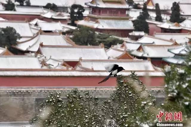 After the snow city
21st, the strong blast of cold air since the second half of this year, China will usher in the first snow of the year. (For details, see: cold cold cold! East on "freezing" mode 30 over the same period the coldest week hits! ), Cooling rate, feeling cold, one of the main characteristics of cold. Today 18 o'clock, Orange cold wave warning was issued by the Central meteorological station.
5 provinces such as Anhui, Henan local cooling Super 16 c
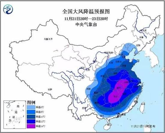
Is expected, under the influence of cold waves, the night of 21st to 24th, most of East-Central China from North to South has widespread strong wind weather, temperatures falling to 6~10℃.
Among them, Huang Huai Central and Western, Eastern, southern Shaanxi, Central and Western, jianghan, South Central and Western regions, South China Northern and northeastern Sichuan, Chongqing East, East, temperatures will drop 12~14℃ in Guizhou, Henan to the South, West, Central and eastern Hubei, Anhui, Hunan, Guangxi and other places in the Northeast part of cooling up to 16 above.
The area accompanied by 4~6 northerly, Eastern and southern sea level wind 7~8, gust 9~10 level.
The cold wave in the end how "cold"?
From the Meteorological Department, the cold snap should not be underestimated. How fierce is then?
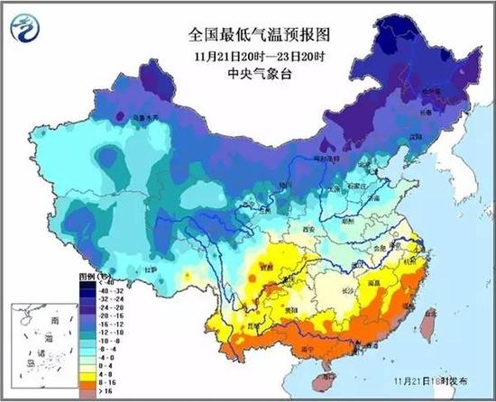
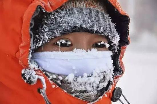
In addition to local cooling will exceed 16 degrees Celsius, the temperature will be the lowest since the beginning of winter. The cold weather will lead China to appear since this winter minimum temperatures in some areas may also be broken history. 24th, minimum temperatures in the North of North China plain to reach-10 ℃, minimum temperature 0 ℃ line north of Jiangnan, South South and South North lowest temperature will reach 4~8℃! By then, recently also show small southern partners with short sleeves long Johns (even long Johns, pants) upper body!
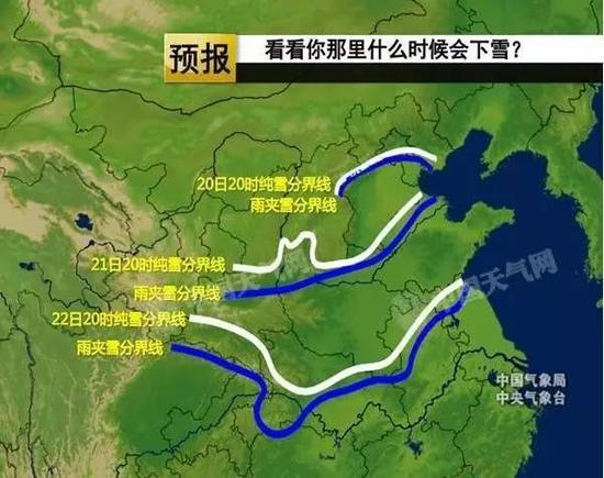
North Blizzard, heavy precipitation in the South. Since yesterday, encountered widespread rain and snow in North China, Beijing, Tianjin and other places in this early winter snow. As cold air continues to the South to "walk", under the influence of the warm, humid air of common, Shaanxi in the North, Huang-Huai and the South, jianghan and huaihe River and other places may be welcome in the current round of snow this winter.
Moreover, in addition to low temperatures, rain and snow, a cool area above with 4~6 northerly, Eastern and southern wind, Xinjiang. Intense cold, coupled with rain (snow), water, high winds as "accomplices", body temperature is colder, the "cool acid", think of shivering!
"Freeze you cry" where cold wave coming from?
When it comes to cold snap where it came from, there must be many smaller partners mouth: Siberia! Because the impression in the cold air seems to have come from there. As in the weather forecast, you often hear "a unit from the Siberian cold front arrived this morning in North Xinjiang......" in that case. And cold as the cold air of the highest level, is certainly no exception.
The answer on the right, but not accurate. In simple terms, the cold wave came to China, usually after three "nest", a "gas stations", four "ordinary".
The three "the nest"
Are three main source of cold air: first, Iceland South Ocean, new sea west of the island is the second, third, new ocean east of the island.
These three sources are in the high latitudes, year-round Sun slanted or rarely see the Sun, the ground receives less solar heat, the temperature is very low, such as the Arctic winter temperatures below-20 c, minimum up to -60~-70 ℃, the average temperature in January is often below-40 c, cold air can be said to be a good "base".
A "filling station"
In these three sources of cold air in the 95% of the central region of cold air passes through Siberia, and accumulate there strengthened, can be said to be cold air South of the important "filling station" also known as "cold key area".
Siberian cold, cold winters and long, mostly at -20~-45 c mean annual temperature is lower than 0 ℃. Just three days before the cold snap arrived in China, many parts of Siberia has dropped to below-40 c.
Four "ordinary"
After Siberia's "transit", it comes to China there are four main roads:
First path West, cold air at latitude 50 ° South, along the direction from West to East into Xinjiang, China, and then west along the river corridor, East of the Qinghai-Tibet plateau to the South;
Second path known as Xibei road (also known as road), cold air South along the great bend of the main central via Mongolia to China, reaching to the middle and lower reaches of the Yangtze River and South China;
Third path known as the East, cold air moving through the eastern part of Mongolia to Northeast China, North China, and then spread from the Yellow River to the South;
Fourth path known as East and West Road, East Road, cold air from the South of the Yellow River, cold air from Eastern Qinghai, West Road to the South, two along the cold front in the South of the Yellow River to the Yangtze River "realignment", then outbreaks affecting the Yangtze River and South China regions to the South.
Different paths of the cold wave, the strength and the weather conditions are very different. Specific to the cold, the cold air of "workhorse" is mainly coming from the road in the Northwest.
"High cool" cold waves do?
1. When the temperature drops, and more clothes to keep warm in a timely manner, in particular, to note the warm hands, face, to avoid frostbite.
2. Beware of cold snap brings gales, doors and Windows and hoardings, scaffoldings, temporary structures such as wind blows structures reinforcement, proper placement of outdoor goods susceptible to wind.
3. Use coal stoves for heating (or some old community in the countryside) to keep the room ventilated, ensure that the flue gas discharge correctly into the outdoors without leaking inside, to prevent carbon monoxide poisoning.
4. Avoid walking on ice, in case of slippery fall drive to avoid driving on snow-covered roads, overpasses and bridges.
5. Elderly patients, especially patients with cardiovascular disease, asthma and other temperature-sensitive people try not to go out.
6. Take a rest and not excessive fatigue, the body has enough energy to keep warm.
Responsible editor: Wei chun
Article keywords:Cold cold air China
I want feedback
Save a Web page
CCTV
中国开启“速冻模式” 这股寒潮究竟从哪来?|寒潮|冷空气|中国_新闻资讯
△ 雪后的紫禁城 21日开始,今年下半年以来最强冷空气来袭,中国多地将迎来今年的第一场雪。(详情见:冷冷冷!中东部开启“速冻”模式 30年同期最冷一周来袭!)降温幅度大、体感湿冷是这次寒潮的主要特点。中央气象台今日18时继续发布寒潮橙色预警。
河南安徽等5省区局地降温可超16℃
预计,受寒潮影响,21日夜间至24日,中国中东部大部地区将自北向南先后出现大范围大风降温天气,平均气温将普遍下降6~10℃。
其中,陕西南部、黄淮中西部、江淮中西部、江汉、江南中西部、华南北部以及四川东北部、重庆东部、贵州中东部等地气温将下降12~14℃,河南南部、安徽西部、湖北中东部、湖南大部、广西东北部等地的部分地区降温可达16℃以上。
上述地区伴有4~6级偏北风,东部和南部海区风力有7~8级,阵风9~10级。
这次寒潮到底有多“冻人”?
从气象部门的动作来看,此次的寒潮确实不容小觑。那么具体有多凶猛呢?
除了局地降温将超16℃,多地气温将创入冬以来新低。此次寒潮天气将致使中国多地出现今年入冬以来最低气温,部分地区还可能破历史记录。其中24日凌晨,华北平原北部最低气温将达到-10℃左右,最低温度0℃线将位于江南北部,江南南部和华南北部最低气温将达到4~8℃!届时,近日还在秀短袖的南方小伙伴们也该秋裤(甚至毛裤、棉裤)上身了!
北方有暴雪、南方强降水。从昨天开始,华北地区遭遇大范围雨雪天气,北京、天津等地迎来今冬初雪。而随着冷空气的不断向南“走”,受其和暖湿气流的共同影响,华北、黄淮、陕西中南部、江汉江淮等地都可能在本轮过程中迎来今冬的初雪。
另外,除了低温、雨雪外,上述降温地区还伴有4~6级偏北风,东部和南部海区风力有7~9级。强烈的低温,再加上雨(雪)水、大风作为“帮凶”,体感温度将更加寒冷,那种“酸爽”,想想都直哆嗦!
“冻哭你”的寒潮从哪来?
说到寒潮从哪里来,肯定有不少小伙伴张口就来:西伯利亚!因为在大家印象中,冷空气好像都来自那里。如在天气预报中,经常会听到“一股从西伯利亚来的冷空气前锋今天上午到达新疆北部……”这样的话。而寒潮作为冷空气中的最高等级,肯定也不例外。
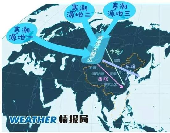
这个答案说对也对,但不够准确。简单来说,寒潮不远万里来到中国,通常要经过三个“老窝”、一个“加油站”、四条“寻常路”。
三个“老窝”
其实是冷空气的三个主要发源地:一是冰岛以南洋面上,二是新地岛以西洋面上,三是新地岛以东洋面上。
这三个源地都在高纬度,常年受太阳光的斜射或很少见到太阳光,地面接收太阳光的热量较少,温度很低,如冬季北冰洋地区气温经常在-20℃以下,最低时可达-60~-70℃,1 月的平均气温常在-40℃以下,可以说是冷空气良好的“生产基地”。
一个“加油站”
在这三个冷空气源地中,95%的冷空气都要经过西伯利亚中部地区,并在那里积累加强,可以说是冷空气南下的重要“加油站”,那里也因此被称为“寒潮关键区”。
所以西伯利亚的寒冷也可想而知,冬季寒冷漫长,大部分都在-20~-45℃,年均气温低于0℃。就在此次寒潮到达中国的前三天,西伯利亚的很多地方已经降到了-40℃以下。
四条“寻常路”
经过西伯利亚的“中转”后,来到中国主要有四条路可以走:
第一条路径称为西路,冷空气在北纬50°以南,基本沿自西向东方向进入中国新疆,然后沿河西走廊、青藏高原东侧南下;
第二条路径称为西北路(又称中路),冷空气主力经蒙古国中部到中国河套一带南下,直达长江中下游和华南地区;
第三条路径称为东路,冷空气经蒙古国东部移到中国东北、华北地区,然后从黄河下游扩散南下;
第四条路径称为东路加西路,东路冷空气从黄河下游南下,西路冷空气从青海东部南下,两股冷空气在黄河以南到长江一带“会师”,然后向南爆发影响江南、华南地区。
不同路径的寒潮,其强度和造成的天气情况有很大差异。具体到此次寒潮过程,其冷空气的“主力”主要是从西北路过来。
面对“高冷”寒潮该怎么办?
1。当气温骤降时,要及时添衣保暖,特别是要注意手、脸的保暖,避免冻伤。
2。谨防寒潮带来的大风,将门窗、围板、棚架、临时搭建物等易被大风吹动的搭建物加固, 妥善安置易受大风影响的室外物品。
3。使用煤炉取暖(多在乡村或一些老旧小区)要注意保持房间通风,确保炉烟正确地排放到户外而不泄漏在室内,防止一氧化碳中毒。
4。避免在冰上行走,以防路滑跌倒;开车尽量避免行驶在冰雪覆盖的道路、立交桥和桥上。
5。老弱病人,特别是心血管病人、哮喘病人等对气温变化敏感的人群尽量不要外出。
6。注意休息,不要过度疲劳,让身体拥有足够的能量用来保暖。
责任编辑:隗俊
文章关键词: 寒潮 冷空气 中国
我要反馈
保存网页
央视