Foreign Media: India police shot at South Tibet protesters 2 dead, 10 injured
Network synthesis of Tibet to foreign media reports, China, India, "Arunachal Pradesh" (that is, Southern Tibet, China) electric last week struck police officers and hundreds of civilians shot in Mong Kok area, resulting in 2 deaths, more than 10 people were injured.
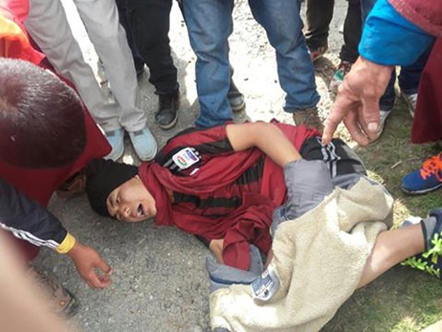
It is reported that local people were dissatisfied with India Government dams in tawang and demonstrations. The demonstrators said dams would caused rivers to flood throughout tawang region, and the region with religious and historical values.
Earlier, "Abang" police have arrested a Tibetan monk who protested the construction of the dam. The monks enjoyed a high prestige in the local, his arrest intensified conflict between the local people and the police. This in addition to the protest against the construction of dams, demanding the release of one of the purposes of the monks also protested.
India 2008 National hydro-electric power policy, "said Arunachal Pradesh" has 50,000 megawatts of hydro-electric power potential, India one-third of the total hydropower potential. In recent years, "Abang" signed a memorandum of understanding with several power company, plans to build more than 100 more hydro-electric projects, of which 14 projects in tawang.
And start zangmu hydropower station project in China at about the same time, India began in the lower reaches of the Yarlung zangbo River, "Arunachal Pradesh" building 14 hydroelectric projects, in order to establish its "downstream". However, for a variety of reasons, India "Abang" hydro-electric projects struggled.
According to domestic media reports October 2015 shows, "Abang" virtually all of the 14 hydroelectric project stalled, yet there is not a project. 13 projects hampered by a lack of environmental permits, there is only one project reaches financial closure, but no money.
The report also said, under "Arunachal Pradesh" Unfortunately progress of hydro-electric power project, the State's Chief Minister nabamu·Tuji at a hydropower working group meeting in September 2013, anger erupted. Back in February 2008, then-Prime Minister Manmohan Singh is known as the country's first major 3000 MW danba song hydropower project Foundation, but because of the Ministry of the environment is lit red, the project difficult.
One India senior official said India on water resources issues in the action is a response to build a hydropower station in the Yarlung zangbo River in China.
Think of the Asia times, tawang the escalation of violence in India has serious security implications.
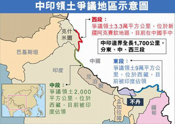
At present, the Sino-Indian border dispute has three sections: the western part of Kashmir, China controls most of the territory; the middle of Himachal Pradesh and Uttar Pradesh, a small piece of territory between; India Northeast "Arunachal Pradesh", all India controls.

The Chinese Government has never recognized the so-called "McMahon line" and "Arunachal Pradesh". Recently, the China United States "' Arunachal Pradesh ' is India a part of" the language requirement United States verified and clarified. (Li Yan, China Tibet online text/images from network)
Related news: India map launched Southern Tibet into a new draft focus
China Tibet online, according to several foreign media reports, India has recently unveiled a new draft map, anyone making "errors and false" map, ranging from fines, to jail. Among them, associated with India over disputed territory between India and Pakistan, sparked widespread media attention. United States Washington considers India requires much more than his actual control of the territory, India was attempting to put their uncontrolled area into himself. United Kingdom's daily mail also published on the border issue, India in the wake of the article, said the draft was India trying to "symbol of illusion" as "fact" is another example.
 Sketch map of disputed area
It was reported that a new Bill called the Act on supervision of geo-spatial information, is currently at the draft stage. The draft provides that "any draw, dissemination, publishing or distributing geographic information that contains the error India map, could face up to 1 million rupees (about 15,000 dollars) to 1 billion rupees (about US $ 15 million) fine and/or up to 7 years in prison. "Anyone who, without India government permission to get India's geo-spatial image information. Already have this type of information must be India security applications. This means that Google wants to continue in India provide services such as Google maps, Uber, continues to provide a taxi service, you need to obtain an authorization, and undergo a rigorous review.
The Washington Post said, India wants the world to see the map, that is all the disputed area belongs to India's map. India Government to define its borders, is not under the actual control of the area to develop, but with China and the disputed region of Pakistan, according to India divided interests of.
The daily mail believes that India Government consultations to resolve their border conflict through negotiations, decided to pass a Bill to address, with intent to prevent India people know for a fact these designated "boundary" is not recognized by most countries in the world.

In fact, India on border issues sensitive manifestations is not the first time. Because of their dissatisfaction with Google to Pakistani-administered Kashmir as Pakistani territory, India has condemned twice in 2005 and 2013 on Google. In 2010, the United Kingdom of the Economist calls "boundary problem", India Government to withdraw the publication. In April 2015, the Al-Jazeera television was forced to stop India live 5 days why India monitors declared "Al Jazeera's part of the map is not displayed correctly India territory frontier". In February this year, India patankete (Pathankot) air force base after the terrorist attacks, India did not immediately seek ways to solve the problem of the Government, but the United Nations and China to carry out "diplomatic war" and accused Google of its maps and geo-services provided in sensitive defense-related facilities and high-resolution images of a nuclear power plant ... ...
United Kingdom daily mail think, this items Bill intent through severe punishment errors map information provides who to maintenance national of "security, and sovereignty or territory full", but India Interior Department more should concentrated concern those abuse map information of people and organization, and not building a system to punishment a "service provides business", just is because he with of map "errors" mark has so-called of India border. If the legislation, India will "cut off from the world."
Reports that there is no doubt that this is going to convince anybody, let them believe India unilaterally drawing borders are sacrosanct. Kashmir and Southern Tibet will not be granted to India at all. In this case, such a Bill would only give India manufacturing endless trouble.
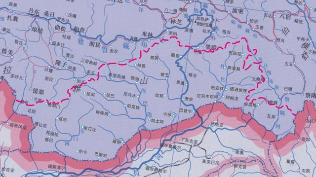 Scholars fill blank map
In April this year, Hao Xiaoguang told the Southern Tibet, a researcher at the Chinese Academy of Sciences Research results, according to the history of Southern Tibet monba and lhoba ethnic origin and geographic distribution of national homogeneity and the related historical events, demonstrates the continuation of the Southern Tibet historically was an important part of China, and recommended in the map of China, Southern Tibet marking the traditional Chinese names.
The Chinese Government has never recognized the so-called "McMahon line" and "Arunachal Pradesh" (that is, Southern Tibet, China). (Guo pan, China Tibet online text/images from the network)
(Editors: Pan Yi burn UN657)
2016-05-12 17:18:03
Integrated
外媒:印度警员向藏南抗议群众开枪 2死10伤
中国西藏网讯 综合外媒报道,印度“阿鲁纳恰尔邦”(即中国藏南地区)警员于上周用电棒敲击并向数百名达旺地区平民开枪,导致2人死亡,10余人受伤。
据悉,当地群众因不满印度政府在达旺修建水坝而游行示威。示威者表示,修建水坝将会导致河水淹没整个达旺区域,而该区域有着宗教与历史价值。
早些时候,“阿邦”警方逮捕了一名抗议修建水坝的藏僧。该僧人在当地享有很高的声望,他的被捕激化了当地民众与警方之间的矛盾。此次除了抗议修建水坝,要求释放该僧人也是示威抗议的目的之一。
印度2008年颁布的国家水利发电政策称,“阿鲁纳恰尔邦”有5万兆瓦的水利发电潜力,占印度总水电潜力的三分之一。近年来,“阿邦”与几家电力公司签署了谅解备忘录,计划建设100多个水电项目,其中14个项目都在达旺地区。
与中国启动藏木水电站工程差不多同一时间,印度开始在位于雅鲁藏布江下游的“阿鲁纳恰尔邦”修建这14个水电项目,以此来确立自己的“下游权利”。但是由于各种各样的原因,印度在“阿邦”的水电项目举步维艰。
据境内媒体2015年10月的报道显示, “阿邦”的这14个水电工程几乎都停滞不前,尚没有一个项目开工。13个项目因缺少环保许可而受阻,只有一个项目达到财务收尾,却没钱了。
报道还称,迫于“阿鲁纳恰尔邦”水力发电项目令人遗憾的进展状况,该邦首席部长纳巴姆·图基在2013年9月的一次水电工作小组会议上怒火爆发。早在2008年2月,时任总理辛格就为号称全国第一大的3000兆瓦丹巴曲水电项目奠基,但由于环境部亮起红灯,该项目寸步难行。
一位印度高级官员曾表示,印度在水资源问题上采取的行动是对中国在雅鲁藏布江建水电站的一种回应。
《亚洲时报》认为,达旺发生暴力升级对于印度而言有着严重的安全隐患。
目前,中印有争议的边界线有三段:西段的克什米尔地区,中国控制着大部分领土;中段喜马偕尔邦和北方邦之间的一小片领土;印度东北部的“阿鲁纳恰尔邦”,全部被印度控制。
中国政府从未承认过所谓的“麦克马洪线”和“阿鲁纳恰尔邦”。近日,中国就美国“‘阿鲁纳恰尔邦’是印度的一部分”这一言论要求美国进行核实和澄清。(中国西藏网 文/李艳 图片来自网络)
相关新闻:印度出台地图新草案 藏南地区成焦点
中国西藏网讯 据多家外媒报道,印度近日出台了一项新的地图绘制草案,称任何人制造“错误和虚假”的地图,轻则罚款,重则坐牢。其中,由于涉及到印巴及中印争议的领土,引发了媒体的广泛关注。美国《华盛顿邮报》认为,印度要求的领土比自己实际控制的多, 印度是妄图将自己未控制的地区纳为己有。英国《每日邮报》也发表《在边境问题上,印度该清醒清醒了》的文章,称该草案是印度试图将“虚幻的象征”当做“事实”的又一例证。
中印领土争议地区示意图 据报道,新法案名为《地理空间信息监管法案》,目前处于草案阶段。该草案规定:“任何绘制、传播、出版或分销含有错误地理信息的印度地图,将面临100万卢比(约合1.5万美元)到10亿卢比(约合1500万美元)的罚款,以及/或者长达7年的监禁。”任何人未经印度政府许可不得获取印度的地理空间图像资料。已拥有这类资料的公司必须向印度安全部门提出申请。这意味着谷歌要想继续在印度提供谷歌地图等服务,Uber等继续提供打车服务,就需要获得相关授权,并经过严格审查。
《华盛顿邮报》称,印度想要让世界看到的地图,即是所有争议地区都属于印度的地图。印度政府对于其边界的界定,并非根据其实际控制的地区来制定,而是将其与中国以及巴基斯坦有争议的地区,按照符合印度利益的方式进行划分。
《每日邮报》认为,印度政府无法通过谈判协商来解决边界冲突,就决定通过一项法案来解决,意图阻止印度人知道事实上这些划定的“边界”是不受世界上大多数国家认可的。
事实上,印度在边境问题上的敏感表现已非首次。由于不满谷歌将巴控克什米尔地区当作巴基斯坦领土,印度曾于2005年和2013年两次对谷歌表示谴责。2010年,英国的《经济学人》因所谓的“边界问题”,被印度政府要求撤回出版。2015年4月,卡塔尔半岛电视台被迫停止印度直播节目5天,原因即为印度监测员宣布“半岛电视台的部分地图没有清楚正确地显示印度领土疆域”。今年2月份,在印度帕坦科特(Pathankot)空军基地遭遇恐怖袭击之后,印度政府并未立即寻求解决问题的方法,而是在联合国与中国开展“外交战”,并指责谷歌在其地图和地球服务中提供敏感国防设施和核电站的高清图像……
英国《每日邮报》认为,这项法案意图通过严厉惩罚错误地图信息提供者来维护国家的“安全、主权或领土完整”,但印度内政部更应该集中关注那些滥用地图信息的人和组织,而不是构建一个体系去惩罚一个“服务提供商”,仅仅是因为他用的地图“错误”标记了所谓的印度边界。若此法案出台,印度将“与世界隔绝”。
报道称,毫无疑问,这根本不会说服任何人,让他们相信印度单方面绘制的边界是神圣不可侵犯的。克什米尔地区和藏南地区不会理所当然的归印度所有。在这种情况下,这样的法案只会给印度制造无穷无尽的麻烦。
学者为空白地图补名 今年4月,中科院研究员郝晓光讲述了对藏南地区的研究成果,根据藏南地区门巴族和珞巴族的历史渊源及地理分布,从民族同源性及相关历史事件的延续等方面论证了藏南地区历史上就是中国的重要组成部分,并建议在《中国地图》的藏南地区标注中国传统地名。
中国政府从未承认过所谓的“麦克马洪线”和“阿鲁纳恰尔邦”(即中国藏南地区)。(中国西藏网 文/郭盼 图片均来源于网络)
(责任编辑:潘奕燃 UN657)
2016-05-12 17:18:03
综合