Behind the Wuhan emergency: satellite images revealed Lakes filling process (map)
After days of record rainfall, rivers, lakes and water level surge effect, the current serious waterlogging in Wuhan City, hundreds of the town were flooded and traffic gridlock, power in some areas, disruption of communication.
At present, Wuhan has started drainage red alert, enterprises, adjust work hours and travel less.
A webcast, we saw the traffic gridlock, islands of land, buses surfing, closed in the city. Netizens have joked, later married to Wuhan new standard: houses, cars, boats.
Ridicule, while is a reflection on the disaster.
Wuhan water Bureau said 6th Wuhan is still "see the sea" are low-lying, heavy rains frequently, low construction standards of the drainage system causes. But it was not to be ignored, along with the rapid pace of expansion of the city, a large number of lakes are filled, water receiving capacity is greatly reduced, the waterlogging hazard is greatly deteriorated.
At present Wuhan urban Lake, 38, and at the beginning of the founding of new China, the figure was 127-60 years Wuhan City nearly 90 lakes disappear. In order to develop, people compete for space, competition for resources into the Lakes, lakes, the Lake filled Lake City, stopped farming, today, taste bitter.
History of Google Earth pictures, we see traces of the lakes are artificial reconstruction of Wuhan.
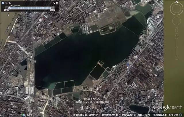
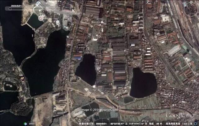
Sand Lake, was second only to East Lake in Wuhan City's second-largest "Lake City". In recent years, first in 2000, build friendship Avenue to fill part of the sand Lake, subsequently, accompanied by a boom in real estate development, residential and office buildings half further sand encroachment.
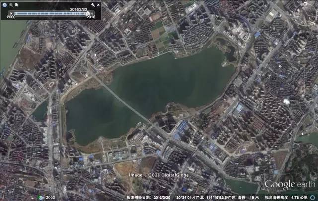
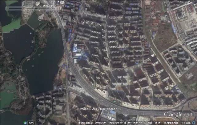
Look at 2000 years of shahu in contrast to 2016 Sand Lake. 16 uninterrupted filling Lakes development, from North Sand Lake squeezed in all directions, was buried by yellow-brown land Green Lake. A Chu-Han road, shahu axed.
Sand Lake
The year 2000.11.1
The year 2016.2.20
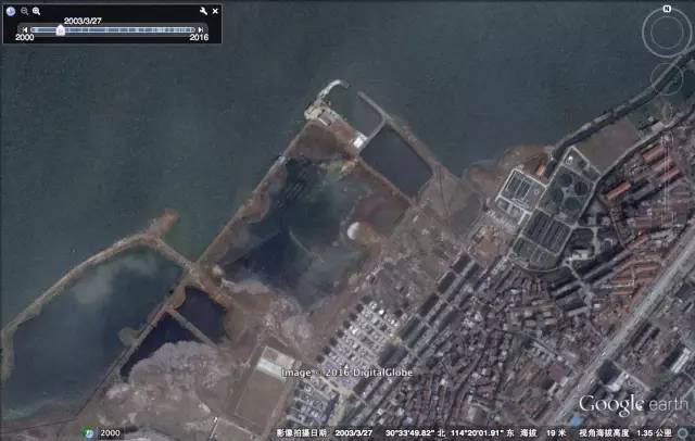
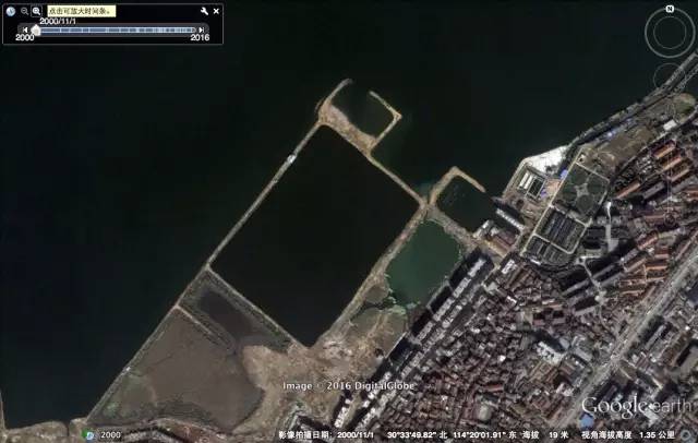
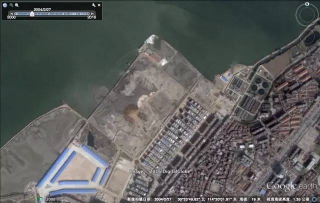
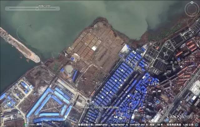
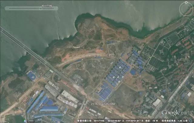
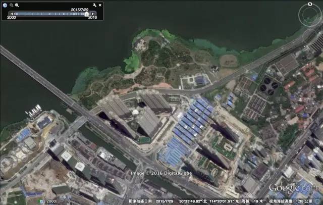
Interception of the southwest corner you can also see a change of the calendar year. 2000 pools of clear water, March 27, 2003 saw the landfill operations over the next few years building 2011 landfill further expansion, by the year 2015, a few high-rise buildings are springing up.
Sand Lake
The year 2000.11.1
The year 2003.3.27
The year 2004.2.27
The year 2009.2.27
The year 2011.7.29
The year 2015.7.29
Were engulfed by the endless wave of development, is more than sand. Let me give a few examples.
16 vanishing off the horse Lake, two lakes were completely engulfed in the new homes.
Horse Lake
The year 2000.9.21
The year 2016.2.20
In fact, such as East Lake, sand Lake, noticeable in the urban area of the Great Lakes, is favored. More unnamed Lakes, is quietly disappearing.
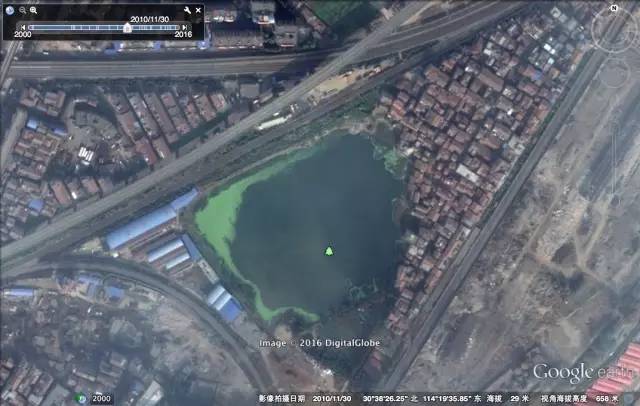
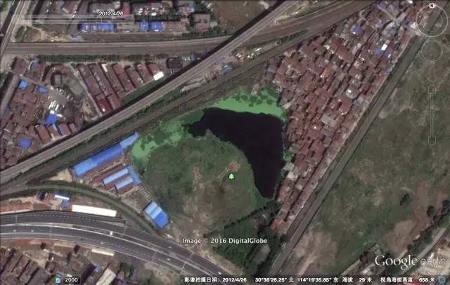
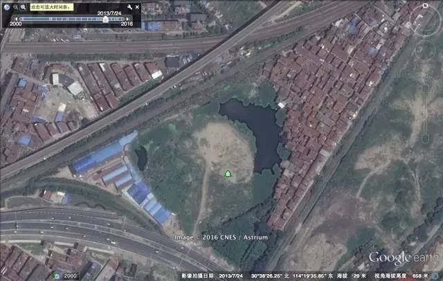
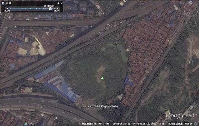
For example, er Huan River to the North of the small lake gradually filled in five years will remain intact. Pictures below show changes in starting in 2010.
Unnamed Lake
The year 2010.11.30
The year 2012.4.26
The year 2013.7.24
The year 2014.7.21
In March 2002, promulgated and implemented the regulations on protection of Lake in Wuhan, this lake is the first of the comprehensive and integrated management of local regulations. Which was followed by a series of corresponding regulations.
At the end of 2009 the highest international Lake community event World Lakes Conference, Wuhan, Wuhan to organizers who publish the Declaration of commitment to the world: "actively encourage public participation in the Lakes, so that activities related to public awareness and promote the work of Lakes".
Shit happens, record rainfall around we cannot. Also to all fighting in the front line pays tribute to the garrison, officials and the masses, is not easy. But we also Revere nature, attention to nature's warning: "Lake City" it's time to make them rest.
(Editors: Dou Yuan UN833)
2016-07-09 13:15:42
People's daily-people's daily
武汉告急背后:卫星图揭示湖泊填埋进程(图)
连续多日创记录的强降雨后,受江河湖库水位暴涨影响,当前武汉城区渍涝严重,全城百余处被淹,交通瘫痪,部分地区电力、通讯中断。
目前,武汉已启动排渍红色预警,企事业单位调整上班时间,减少出行。
通过网络直播,我们看到了交通瘫痪,陆地变孤岛,巴士在冲浪,全市停课。网友们调侃说,以后武汉人结婚新标配:房、车、船。
调侃之余,是对这次灾难的反思。
武汉市水务局6日表示,武汉依然“看海”有地势低、暴雨频发、排水系统建设标准偏低等原因。但不容忽视的是,伴随城市快速扩张的步伐,大量湖泊被填埋,纳水能力大为降低,让此次内涝的危害大为恶化。
目前武汉城区湖泊有38个,而在新中国成立初期,这一数字是127个——60年来武汉城区近90个湖泊消失。为了发展,人们向湖泊争夺空间、争夺资源,围湖造田、填湖建城、拦湖养殖,如今,尝到了苦果。
通过谷歌地球的历史图片,我们清晰地看到了武汉湖泊被人为改造的痕迹。
沙湖,曾是武汉市仅次于东湖的第二大“城中湖”。近年来,先是在2000年,兴建友谊大道填占部分沙湖,随后,伴随着房地产开发的热潮,小区和办公楼进一步将沙湖蚕食一半。
看看2000年的沙湖与2016年的沙湖对比。16年的不间断填湖开发,把沙湖从东南西北各个方向挤压,绿色的湖水被黄褐色的土地掩埋。一条楚汉路,将沙湖拦腰截断。
沙 湖
2000.11.1
2016.2.20
截取西南一角,亦可看出历年的变迁。2000年的一汪碧水,2003年3月27日可看见填埋作业,随后几年展开建设,2011年填埋范围进一步扩张,到了2015年,几栋高层住宅拔地而起。
沙 湖
2000.11.1
2003.3.27
2004.2.27
2009.2.27
2011.7.29
2015.7.29
被无止境的开发浪潮吞噬的,何止是沙湖。再举几个例子。
16年间逐渐消失的下马湖,两个湖面完全被新建住宅吞没。
下马湖
2000.9.21
2016.2.20
其实,如东湖、沙湖等市区内引人注目的大湖,已经算是受到优待了。更多的无名湖泊,正在默默无闻地消失中。
比如,二环线北侧靠江的这个无名小湖泊,五年来逐步被填埋蚕食。下列图片分别显示了从2010年开始的变化。
未名小湖
2010.11.30
2012.4.26
2013.7.24
2014.7.21
2002年3月,武汉颁布实施了《湖泊保护条例》,这是我国第一部对湖泊进行全面、综合性管理的地方性法规。随后又通过了一系列相应法规。
在2009年底的国际湖泊界最高盛会世界湖泊大会上,武汉以主办方身份发布《武汉宣言》,向世界承诺:“积极鼓励公众参与湖泊治理,让公共意识和有关活动推进湖泊治理工作”。
天有不测风云,创记录的降雨我们无法左右。也向所有奋战在一线的解放军、官员、群众致敬,太不容易了。但我们也要敬畏大自然,重视大自然的警示:“百湖之城”是时候让湖泊休养生息了。
(责任编辑:窦远行 UN833)
2016-07-09 13:15:42
人民网-人民日报