Fourth, the first images released China's meteorological satellite "complete upgrade"
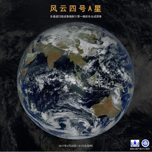 Fourth, a star of the first color composite image
People's daily Beijing, February 27 (Zhao Zhuqing) this morning, the National Defense Science and Industry Bureau, the China Meteorological Administration jointly issued a new Chinese geostationary meteorological satellite FY-fourth gets first batch of images and data. This shows that, fourth satellite matches, working in coordination with ground application system normal Chinese geostationary meteorological satellite was successfully upgraded.
Fill many blanksDefense Science and Industry Bureau Chief Tian Yulong introduce, after producing its first batch of images and data analysis, image clear, clouds and the surface texture is rich, full validation of the main detection function of the fourth satellite, integrated the ability to reach the international advanced level.
Fourth satellite is geostationary orbit meteorological satellites in China from the first generation (second) to the second generation across the first star, launched on December 11, 2016 at the Xichang satellite launching Center, 5 times after the orbit maneuver, December 17, successfully positioned at 99.5 degrees East longitude over the equator, and officially named the fourth a star.
On Star equipped with multi-channel scanning radiometer, Interferometer atmospheric sounding, lightning imager and space weather monitors, 4 sets of remote sensing instruments, interferometric atmospheric sounding filled world of observation in the field blank, the Lightning Imaging instrument to fill the gaps in observations in the field in China.
Capacity upgradeCompared with the first generation geostationary meteorological satellite, FY-fourth unique what? Tian Yu-long told reporters that the fourth observation time resolution of 1 time, improves spatial resolution 6 times, atmospheric temperature and humidity observation capacities increased a thousandfold, 160 times times more the amount of satellite observation data, observing the product quantity increases 3 times.
Director of the national satellite meteorological center said Yang, fourth, longer life, and information gets faster and more powerful. "Intuitive and newly acquired satellite images more details compared to the previous generation, more real, more rich. ”
"Run" to "leader"Tian Yulong introduces fourth satellite is China Aerospace Science and technology innovation of new achievements, and achieved a number of major technological breakthroughs.
First, 4 sets of remote sensing instruments mounted on a satellite platform, successfully resolved the problem of mutual interference generated by multiple instruments at the same time, using a satellite to achieve multiple functions, saving significant development costs.
II is the world's first geostationary high spectral atmosphere vertical observations, for high frequency, high precision vertical atmospheric observation for structure of atmospheric temperature and humidity information will vigorously promote weather forecast accuracy and raise the level of refinement.
Independent breakthrough third geostationary three-axis stabilized platform navigation image registration techniques, image positioning accuracy to achieve world-class levels.
Four is the first Chinese geostationary Imaging observations of lightning, lightning in China and neighboring areas can be shoot 500 pictures per second, for the monitoring and tracking of severe convective weather provides a new means of observation, will improve the level of monitoring and early warning of disasters such as heavy rain and lightning.
In addition, space weather detection of significant increase in the number of channels and exploration elements, significantly improve the accuracy, will further enhance China's space weather monitoring capabilities.
The service "along the way"Currently, Defense section workers Council, and China Meteorological Bureau is by plans organization units carried out satellite in rail test, plans this year June-July delivered using, synchronization organization power in weather forecast, and disaster mitigation, and should climate changes, and resources development, and ecological environment monitoring and space weather warning, field carried out application research, active promoted in water, and agricultural, and forestry, and environment, and mitigation, and marine, and energy and aviation, industry of application.
And, fourth, will also "along the way" countries along with high accuracy of meteorological satellite data, and provide support for the joint construction of disaster prevention and mitigation system, play a role in the economic and social development of the countries of the region, reflecting China's important contribution to the international community to further improve China's space industry and the Meteorological Service's international standing and influence.
So far, China has successfully launched 15 weather satellite, with 8 satellites in orbit to achieve operational and meteorological satellite series, as only a few have both polar orbiting and geostationary orbit meteorological satellites of the country.
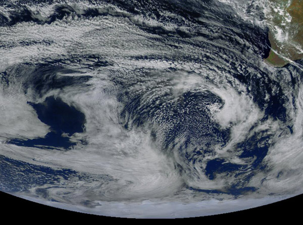 Monitoring of Antarctic Vortex
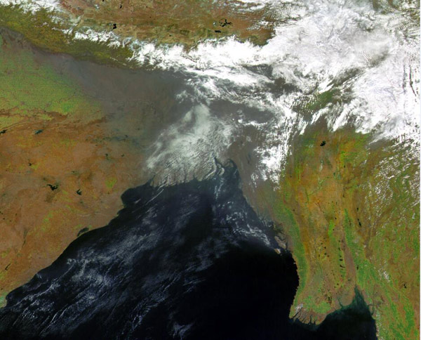 Bay of Bengal haze monitoring
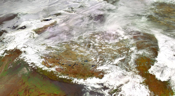 Monitoring on the Tibetan plateau
(Source: people's daily online-technology channel)
(Editors: Zhong Qinghui UN660)
2017-02-27 13:36:00
People's daily online
风云四号首批图像发布 中国气象卫星“完全升级”
风云四号A星第一幅彩色合成图像 人民网北京2月27日电(赵竹青)今天上午,国防科工局、中国气象局联合发布了中国新一代静止轨道气象卫星风云四号获取的首批图像与数据。此举表明,风云四号卫星与地面应用系统协调匹配、工作正常,标志着中国静止轨道气象卫星成功实现了升级换代。
填补多项空白 国防科工局总工程师田玉龙介绍,经过对首批获取的图像和数据初步分析,图像层次分明,云层和地表纹理丰富,风云四号卫星的主要探测功能得到全面验证,综合探测能力达到国际领先水平。
风云四号卫星是中国静止轨道气象卫星从第一代(风云二号)向第二代跨越的首发星,于2016年12月11日在西昌卫星发射中心成功发射,经过5次机动变轨后,12月17日成功定点于东经99.5°赤道上空,并正式命名为风云四号A星。
星上搭载多通道扫描成像辐射计、干涉式大气垂直探测仪、闪电成像仪和空间天气监测仪等4台遥感仪器,其中干涉式大气垂直探测仪填补了世界在该领域观测的空白、闪电成像仪填补了中国在该领域观测的空白。
能力全面提升 与第一代静止轨道气象卫星相比,风云四号的独特之处在哪?田玉龙告诉记者,风云四号观测的时间分辨率提高了1倍,空间分辨率提高了6倍,大气温度和湿度观测能力提高了上千倍,整星观测数据量提高了160倍,观测产品数量提高了3倍。
国家卫星气象中心主任杨军表示,风云四号卫星寿命更长,信息获取速度更快,功能更强大。“直观来看,新获取的卫星云图相比上一代细节更多,色彩更真实、更丰富。”
“并跑”到“领跑” 田玉龙介绍,风云四号卫星是中国航天科技自主创新的新成就,实现了多项重大技术突破。
一是将4台遥感仪器安装在一个卫星平台上,成功解决了多仪器同时工作所产生相互干扰的问题,利用一颗卫星实现了多种功能,极大节省了研制成本。
二是世界上首次实现了静止轨道高光谱大气垂直观测,可进行高频次、高精度垂直大气观测,获取大气温湿结构信息,将有力推动天气预报准确率和精细化水平的提高。
三是自主突破了静止轨道三轴稳定平台的图像导航配准技术,使得图像定位精度达到国际一流水平。
四是首次实现了中国静止轨道闪电成像观测,可对中国及周边区域闪电每秒拍摄500张照片,为强对流天气的监测和跟踪提供全新的观测手段,将提高对雷电和暴雨等灾害的监测预警水平。
此外,空间天气探测通道数量和探测要素大幅增加,精度显著提高,将进一步增强中国空间天气监测能力。
将服务“一带一路” 目前,国防科工局、中国气象局正在按计划组织有关单位开展卫星在轨测试,计划今年6月-7月份交付使用,同步组织力量在天气预报、防灾减灾、应对气候变化、资源开发、生态环境监测和空间天气预警等领域开展应用攻关,积极推动在水利、农业、林业、环境、减灾、海洋、能源和航空等行业的应用。
同时,风云四号还将为“
一带一路”沿线国家提供高精度的气象卫星资料,为共同构建防灾减灾体系提供支撑,在区域各国的经济社会发展中发挥作用,体现中国对国际社会的重要贡献,进一步提升中国航天事业和气象事业的国际地位和影响力。
迄今为止,中国已成功发射了15颗气象卫星,其中8颗卫星在轨运行,实现了气象卫星业务化和系列化,成为世界上少数几个同时拥有极轨和静止轨道气象卫星的国家。
南极地区涡旋监测图孟加拉湾北部灰霾监测图青藏高原监测图(来源:人民网-科技频道)
(责任编辑:钟庆辉 UN660)
2017-02-27 13:36:00
人民网