Chinese-made satellite "Takakage first" returns HD Photo: steel structure of bird's nest in Beijing is clearly visible high resolution satellite HD _ | | | news
China Beijing, March 20 Reuters new media first Takakage 0.5-meter commercial remote sensing satellite, first group 01 satellite recently returned a set of HD images. Following is China Aerospace Science and Technology Corporation, Takakage published first part of recent high-resolution satellite image:
> Stadium for the 2008 Beijing Olympics, you can see the stadium erected the freestyle skiing venue.
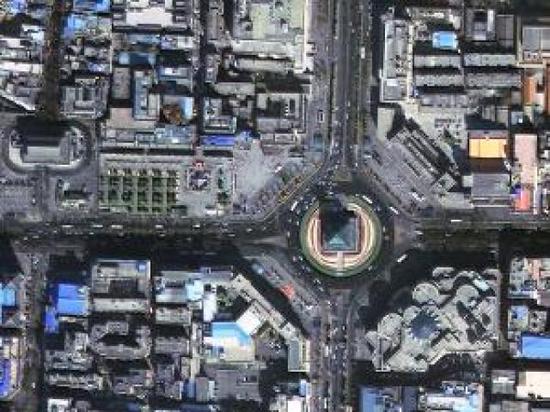
> Figure for the Bell Tower, discs of cars on the road driving directions clearly visible.
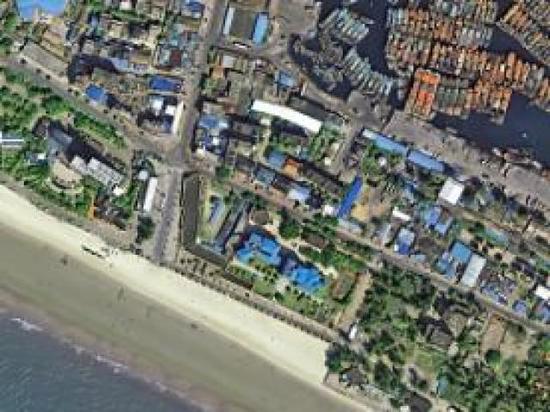
> Figure for the Guangxi Zhuang Autonomous Region of the North Sea shore, a tourist can be seen on the beach.
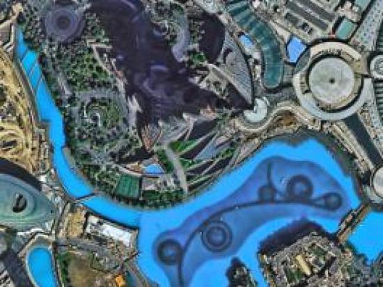
> Figure for the Burj Khalifa, bottom water facilities in a glance.
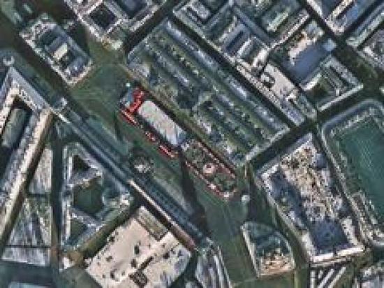
> Figure as red square in Moscow, Russia, red roof is especially significant, the crowd in the square coming and going.
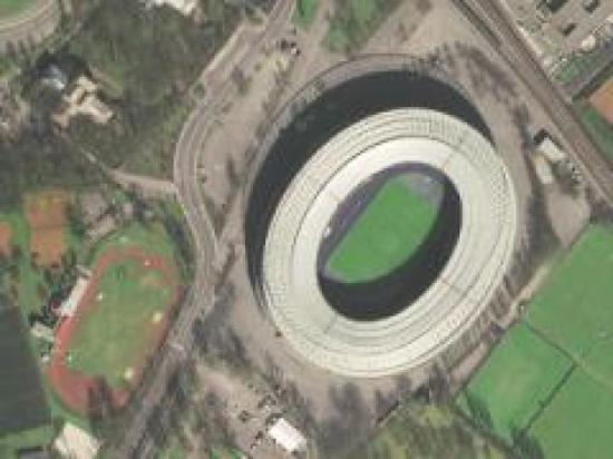
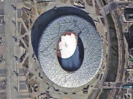
> Figure for Austria's Ernst Happel Stadium, can clearly see the arena bar at the top of the structure.
On December 28, 2016, Takakage 01, first two satellites in the Taiyuan Satellite Launch Center based on double satellite successfully launched an arrow.
It is responsible for the satellite developed by China Aerospace Science and Technology Corporation introduced five aerospace dongfanghong satellite Xiaomin Zhang, Deputy General Manager, Takakage first satellite panchromatic resolution of 0.5 metres, 2 m multispectral resolution, an orbital altitude of 500 km, width of 12 km, with continuous bands, multi stripe mosaic, multiple targets, and stereo and many other imaging modalities. Advanced satellite control system and high integration of electronic systems, light weight and motor ability and excellent image quality up to international standards.
Takakage after the first satellite application, sending back images can be applied to many areas of social development of the country.
Takakage, first commercial operation from China siwei surveying and mapping technology affiliated to China Aerospace Science and Technology Corporation Limited. Xu Wen, General Manager of China siwei surveying and mapping technology, Takakage, first to provide users worldwide with high spatial and high temporal and high spectral resolution and a Earth observation capacity for the core applications of remote sensing data and value added services, applications and system solutions. Services covering surveying, land and resources survey, urban construction, forestry, water conservancy, geology and mineral resources, environmental monitoring, national security and emergency and disaster reduction, and many other industries. In Internet, location services, Smart City, emerging industries such as finance and insurance also has great potential.
In addition, Takakage first satellite, Google, Baidu, high-site will be able to provide users with more and better high resolution satellite images and further promote the development of Internet map.
It is understood that the end of 2017, 2 high landscape series of satellites will be launched in China, when 4 0.5-meter resolution satellite network run. This will improve domestic long-term dependence on imports of commercial remote sensing satellite images with high resolution.
>: Tang Liu Guangbo
Article keywords:High resolution satellite HD
I want feedback
Save a Web page
Xinhua News Agency
中国国产卫星“高景一号”传回高清图片:北京鸟巢钢结构清晰可见|高分辨率|卫星|高清_新闻资讯
新华社北京3月20日新媒体专电 中国首颗0.5米级商业遥感卫星高景一号01组卫星近日传回一组高清图像。以下是中国航天科技集团公司公布的高景一号卫星近期拍摄的部分高分辨率影像:
>图为2008年北京
奥运会主场馆,可以看到场馆内搭起的自由式滑雪场地。
>图为西安钟楼,圆盘道路上车辆的行驶方向清晰可辨。
>图为广西壮族自治区北海的岸边,沙滩上可以看见不少游人。
>图为迪拜哈利法塔,塔底水中设施一览无遗。
>图为俄罗斯的莫斯科红场,红色屋顶分外显著,广场上的人群来来往往。
>图为奥地利的恩斯特哈佩尔球场,可以清晰看出球馆顶部的钢筋结构。
2016年12月28日,高景一号01组两颗卫星在太原卫星发射中心以一箭双星方式成功发射。
据负责卫星研制的中国航天科技集团公司五院航天东方红卫星有限公司副总经理张晓敏介绍,高景一号卫星全色分辨率为0.5米,多光谱分辨率2米,轨道高度500公里,幅宽12公里,具有连续条带、多条带拼接、多目标和立体等多种成像模式。卫星采用先进的控制系统和高度集成的电子系统,重量轻、机动能力强、图像质量达到国际一流水平。
高景一号卫星投入应用后,发回的影像可广泛应用于国家社会发展的众多领域。
高景一号的商业化运营是由中国航天科技集团公司所属的中国四维测绘技术有限公司负责。中国四维测绘技术有限公司总经理徐文表示,高景一号将为全球用户提供以高空间、高时间、高光谱分辨率和全天候对地观测能力为核心的遥感数据及其增值应用服务,以及应用系统解决方案。服务对象涵盖测绘、国土资源调查、城市建设、农林水利、地质矿产、环境监测、国防安全和应急减灾等众多传统行业。在互联网、位置服务、智慧城市、金融保险等新兴行业也具有巨大的应用潜力。
此外,有了高景一号卫星,谷歌、百度、高德等网站将可以为用户提供更多更好的高分辨率卫星影像,进一步推动互联网地图行业的发展。
据了解,2017年底,中国还将发射2颗高景系列卫星,届时4颗0.5米级分辨率卫星将组网运行。这将改善国内高分辨率商业遥感卫星影像长期依赖进口的局面。
>责任编辑:刘光博
文章关键词: 高分辨率 卫星 高清
我要反馈
保存网页
新华社